Where We Draw the Lines: Weighing Commitments to Community and Heritage
Steve Kosiba
University of Alabama
The AAA Statement of Ethics asks anthropologists to “do no harm,” an injunction that is deceptively simple. After all, anthropologists can rarely foresee or influence the potential consequences and unintentional impacts of their research. The AAA’s injunction therefore introduces thorny issues pertaining to the long-term effects of data—the maps, village boundaries, and ethnographic interpretations—that emerge from anthropological research. We could ask: Who defines harm, both immediate and potential? And perhaps more importantly, how might we recognize the ways our data and our work can cause harm to the collaborators or communities with whom we work?
Such questions often trouble archaeologists, who typically must weigh competing obligations to living communities, cultural heritage institutions, and academia (see AAA Ethics Principle 3; Bria and Cruzado 2015; Silverman 2011). When conducting fieldwork, archaeologists frequently find themselves in tense conversations, informing farmers that their fields contain important ruins. In countries such as Peru or Mexico, this information is not just terminological. It implies a shift in value that can cause harm. By recording cultural remains on field forms, archaeologists draw “sites” on lands of semi-autonomous collectives (comunidades campesinas in Peru or ejidos in Mexico), then submit these maps to national institutions, such as a Ministry of Culture. In doing so, archaeologists convert the land and its attributes to cartographic representations, whereby places become coordinates and distributions of pottery sherds become polygons. Federal institutions use these representations to reclassify select sites as national cultural patrimony, a designation that converts landholdings into a general register of value (“heritage”), but divests communities of land (see also McCoy 2011).

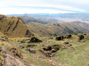
Image 1: The ruins of Huanacauri before our 2014 excavations, Cusco in the background.
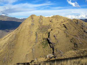
This conversion from community landholding to national heritage, and its implications, became clear to me during my 2014 archaeological and ethnographic fieldwork at Huanacauri, an important Inca temple atop a peak that towers above the former Inca imperial capital of Cusco, Peru. Huanacauri is both a sacred mountain and a small temple complex (one-hectare), both of which have long been essential to Inca and Andean religious beliefs. According to legend, one of the first Incas became a god at Huanacauri. The Incas built a temple on the mountain’s summit where, in ceremonies held during the height of Inca rule, young boys became elites and emperors affirmed their sovereignty. Today, both farmers from Cusco and travelers seeking “mystical” experiences leave offerings for the mountain in hopes of gaining its favor and drawing on its power. Our archaeological and ethnographic research sought to uncover evidence of Inca ritual practices at Huanacauri. We collaborated with both the Peruvian Ministry of Culture (MC) and Kircas, a village of indigenous farmers (campesinos) who live below the peak.

Image 2: Huanacauri, a temple and mountain that embodied Inca imperial power, now Peruvian national cultural patrimony.
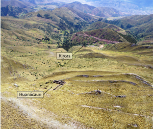
All of these parties—our research team, the MC, and the people of Kircas—were interested in protecting the ruins at Huanacauri. But the MC and Kircas simply could not agree on what the site was. The Peruvian government has established that the site lies within Kircas community land and the District of San Sebastián, Cusco. Kircas community members have protected the site from looters, and defined their community boundary by creating stacks of stones (mojones) above the ruins. But in 2007, the MC proposed a national patrimony site boundary within the community’s land, and suggested that the campesinos could not build, dig, or plant within the boundary. To draw the boundary, the MC registered archaeological features with GPS units, and marked a 2.11 square kilometer polygon around the 1ha of temple ruins (this boundary is still the subject of negotiation, hence I do not provide a map because such data might be implicated in a legal dispute). Importantly, the MC referred to anthropological research, which suggests that the Inca temple of Huanacauri was an extensive “sacred landscape” comprising the temple and environmental features such as springs, ravines, or boulders. The people of Kircas questioned how the MC could draw such an expansive boundary, divesting them of community lands to protect terrain without visible ruins. What is more, they stated that protecting the ruins did not preclude their use of adjacent land, which they and their forbears had long modified by digging small water reservoirs with retention walls. This kind of disagreement is not uncommon in Peru. Indeed, a similar negotiation occurred during the process of delimiting the Inca monumental site of Sacsayhuaman, above Cusco.

Image 3: Oblique aerial photograph showing the peak and ruins of Huanacauri and the village of Kircas. The proposed site delimitation would include much of the land between the peak and the village, as well as adjoining lands. The city of Cusco is visible in the upper right hand corner.
When we initiated the project at Huanacauri, our research team thought that we should maintain neutrality regarding the site boundary in order to maintain ideal collaborative relationships with both parties. Then, the president of Kircas approached me about the issue. He wanted a map. More precisely, he wanted to know how to read and explain a map. I realized that, though we archaeologists often seek neutrality in such situations, our actions and their consequences not only favor one side in these disagreements, but also reproduce power asymmetries between federal institutions and farming communities. This is because our data are largely restricted to academic and institutional spaces and audiences. Moreover, these data are rarely translatable to the people with whom we work. Without access to such data and the knowledge to read them, the people of Kircas had no means to argue against the MC’s definition of a “sacred landscape.” They could not voice their disagreement in the same language as the MC—a cartographic language of contours, coordinates, and quadrants. In conversations with the community, our team realized that our work had to not only map, and share maps, but also teach the process of mapping.
As other blog posts here have suggested, it is often difficult for archaeologists to draw a line that neatly separates community and federal claims to cultural heritage, largely because these definitions pivot on different understandings of “harm.” Here, I shifted focus from the issue of defining harm to the problem of drawing lines—the very literal consequences of drawing lines (as well as coordinates and polygons) on maps. In producing maps, we create data that will outlast current federal regulations and community interests. These data might support claims to land, and do harm, in ways that we cannot currently imagine. We may not be able to prevent this potential harm. But our work requires responsible data dissemination (see AAA Ethics Principle 5), which means that we should seek to share, translate, and teach the process by which we construct knowledge. By doing this, we can help to position a range of actors—local communities, federal institutions, archaeologists—on the same playing field.
REFERENCES
Bria, R.E. and E.K. Cruzado Carranza. 2015. Co-creative approaches to heritage preservation and community development at Hualcayán, Ancash, Peru. Advances in Archaeological Practice 3(3): 208-222.
McCoy, E. 2011. Disputed worlds: Performances of heritage in Cusco’s tourism economy. Rupkatha Journal on Interdisciplinary Studies in Humanities 3(3): 419-425.
Silverman, H. 2011. Contested cultural heritage: A selective historiography. In Contested Cultural Heritage, H. Silverman (ed.), pp. 1-49. New York: Springer.
Filed under: accountability, archaeology, data management, land rights, the state